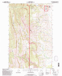
1995 Map of Ear Mountain
USGS Topo · Published 1997About this map
The Sawtooth Range dominates the western half of this Teton County landscape, where the high ridges of the Lewis and Clark National Forest meet the transition into the Ear Mountain State Wildlife Management Area. This territory is defined by its complex drainage systems, with the Teton River and its South Fork flowing near the northern boundary, while a network of creeks including Willow Creek, Deep Creek, and Kings Creek carve through the eastern slopes. A distinct cluster of conservation land appears in the northeast corner at the Pine Butte Swamp Nature Conservancy Preserve, situated just south of Crab Butte. The presence of the Ear Mountain Guard Station and the Gleason Resort indicates the area's dual role as both a managed forest and a destination for recreation along the Front. This 1990s revision carefully tracks the Forest Boundary and numerous survey markers, such as Mon 34 through Mon 41, which delineate these protected Montana lands.
Find a feature on this map
35 named features on this map. Tap any name to fly to it.
Don’t see what you’re looking for? This feature index may not catch every label — zoom into the map to look around manually.
Map Details
Editions of this 1995 Ear Mountain Map
This is the sole edition of this map. No revisions or reprints were ever made.
Other maps of this area

1903 · Saypo
USGS Topo · 1:125,000

1955 · Choteau
USGS Topo · 1:250,000

1957 · Choteau
USGS Topo · 1:250,000

1958 · Choteau
USGS Topo · 1:250,000

1958 · Ear Mountain
USGS Topo · 1:24,000

1958 · Lake Theboe
USGS Topo · 1:24,000

1958 · Cave Mountain
USGS Topo · 1:24,000

1958 · Mount Wright
USGS Topo · 1:24,000
1958 · Twin Lakes
USGS Topo · 1:24,000

1958 · Our Lake
USGS Topo · 1:24,000