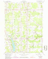
1959 Map of East Claridon
USGS Topo · Published 1979About this map
East Claridon and Huntsburg anchor this rural Geauga County landscape during a period of steady mid-century transition. The Baltimore and Ohio Railroad cuts diagonally through the western portion of the quadrangle, serving the settlements of Claridon and East Claridon as it follows the terrain near the Cuyahoga River. Water management is a central feature of the local geography, dominated by the significant footprint of the East Branch Reservoir with its Spillway Elev 1132 at the southern edge.
Find a feature on this map
52 named features on this map. Tap any name to fly to it.
Don’t see what you’re looking for? This feature index may not catch every label — zoom into the map to look around manually.
Map Details
Editions of this 1959 East Claridon Map
3 editions found
Other maps of this area

1904 · Chardon
USGS Topo · 1:62,500

1905 · Bristolville
USGS Topo · 1:62,500

1905 · Garrettsville
USGS Topo · 1:62,500

1905 · Jefferson
USGS Topo · 1:62,500

1906 · Chardon
USGS Topo · 1:62,500

1907 · Bristolville
USGS Topo · 1:62,500

1907 · Jefferson
USGS Topo · 1:62,500

1907 · Garrettsville
USGS Topo · 1:62,500

1950 · Cleveland
USGS Topo · 1:250,000

1952 · West Farmington
USGS Topo · 1:24,000
Featured Places
- Hambden Township, OH
- Mesopotamia Township, OH
- Burton Township, OH
- Hartsgrove Township, OH
- East Claridon, OH