
1964 Map of East Evacuation Creek
USGS Topo · Published 1968About this map
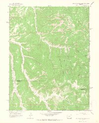
Oil Spring Mountain dominates the northeast corner of this high-plateau landscape along the border of Rio Blanco and Garfield counties. The terrain is defined by a complex network of drainage systems, most notably West Evacuation Creek and East Evacuation Creek, which carve deep passages through the upland. Land use during the mid-1960s is reflected in several industrial and agricultural markers, including scattered Drill Holes and a Corral positioned near the headwaters of Missouri Creek. Evidence of earlier activity is noted with unnamed Ruins located along the southern reaches of West Evacuation Creek. The map documents a primitive transportation network consisting primarily of a Jeep Trail that follows the ridge lines between West End Canyon and Timber Canyon, illustrating the era's reliance on rugged, unimproved roads for accessing these remote petroleum and grazing lands.
Find a feature on this map
21 named features on this map. Tap any name to fly to it.
Don’t see what you’re looking for? This feature index may not catch every label — zoom into the map to look around manually.
Map Details
Editions of this 1964 East Evacuation Creek Map
2 editions found
Other maps of this area

1885 · East Tavaputs
USGS Topo · 1:250,000

1956 · Grand Junction
USGS Topo · 1:250,000

1959 · Grand Junction
USGS Topo · 1:250,000

1960 · Grand Junction
USGS Topo · 1:250,000

1962 · Grand Junction
USGS Topo · 1:250,000

1964 · Grand Junction
USGS Topo · 1:250,000

1964 · Texas Creek
USGS Topo · 1:24,000

1964 · Douglas Pass
USGS Topo · 1:24,000
1964 · Texas Mountain
USGS Topo · 1:24,000

1964 · Baxter Pass
USGS Topo · 1:24,000