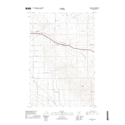
2020 Map of East Kittitas
USGS Topo · Published 2020About this map
The agricultural landscape of East Kittitas and Badger Pocket is defined by a sophisticated network of irrigation infrastructure essential for high-desert farming. This 2020 record shows the complex paths of the Cascade Canal, N Br Canal, and specialized conduits like Gravity Ditch and Turbine Ditch that feed the fields below the Boylston Mountains. The transition from rail transport to recreational use is clearly visible as the Palouse To Cascades State Park Trail follows the former railroad grade through Johnson Canyon and past the site of Renslow. The map details a dense grid of family and service roads, including Glover Rd and Hamilton Rd, which connect remote farmsteads to the larger valley. The terrain shifts from the irrigated flats of the south to the higher, arid ridges of the north, reflecting the ongoing management of water in this part of Kittitas County.
Find a feature on this map
54 named features on this map. Tap any name to fly to it.
Don’t see what you’re looking for? This feature index may not catch every label — zoom into the map to look around manually.
Map Details
Editions of this 2020 East Kittitas Map
This is the sole edition of this map. No revisions or reprints were ever made.
Other maps of this area

1920 · Colockum Pass
USGS Topo · 1:125,000

1922 · Colockum Pass
USGS Topo · 1:125,000

1938 · Badger Pocket
USGS Topo · 1:48,000

1939 · Boylston
USGS Topo · 1:48,000

1943 · Boylston
USGS Topo · 1:62,500

1943 · Badger Pocket
USGS Topo · 1:62,500

1950 · Yakima
USGS Topo · 1:250,000

1953 · McDonald Spring
USGS Topo · 1:24,000
1953 · Badger Gap
USGS Topo · 1:24,000
1953 · East Kittitas
USGS Topo · 1:24,000