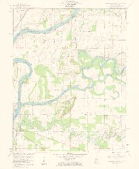
1959 Map of East Mount Carmel
USGS Topo · Published 1961About this map
The confluence of three major river systems dominates this landscape at the boundary of Illinois and Indiana. The Wabash River, White River, and Patoka River converge in a complex network of wetlands and oxbows, including the Cypress Swamps and Claypole Pond. This 1959 survey records the region just before significant modern alterations, showing the vital connection of the Mount Carmel Ferry and the proximity of the Southern and New York Central railroads. The settlement at East Mount Carmel and the smaller hamlet of Orrville sit amidst a terrain marked by the Gordon Hills and historical markers such as the Old Indian Treaty Boundary. Local history is preserved in the locations of the Scott Chapel Cem and Orrville Cem, providing a detailed view of the rural communities and navigation hazards like Kellys Ripple during the mid-century era.
Find a feature on this map
40 named features on this map. Tap any name to fly to it.
Don’t see what you’re looking for? This feature index may not catch every label — zoom into the map to look around manually.
Map Details
Editions of this 1959 East Mount Carmel Map
4 editions found
Other maps of this area

1901 · Princeton
USGS Topo · 1:62,500

1903 · Princeton
USGS Topo · 1:62,500

1903 · Patoka
USGS Topo · 1:125,000

1904 · Mount Carmel
USGS Topo · 1:62,500

1911 · Sumner
USGS Topo · 1:62,500

1913 · Sumner
USGS Topo · 1:62,500

1915 · Vincennes
USGS Topo · 1:62,500

1944 · Vincennes
USGS Topo · 1:62,500

1956 · Vincennes
USGS Topo · 1:250,000

1957 · Vincennes
USGS Topo · 1:250,000