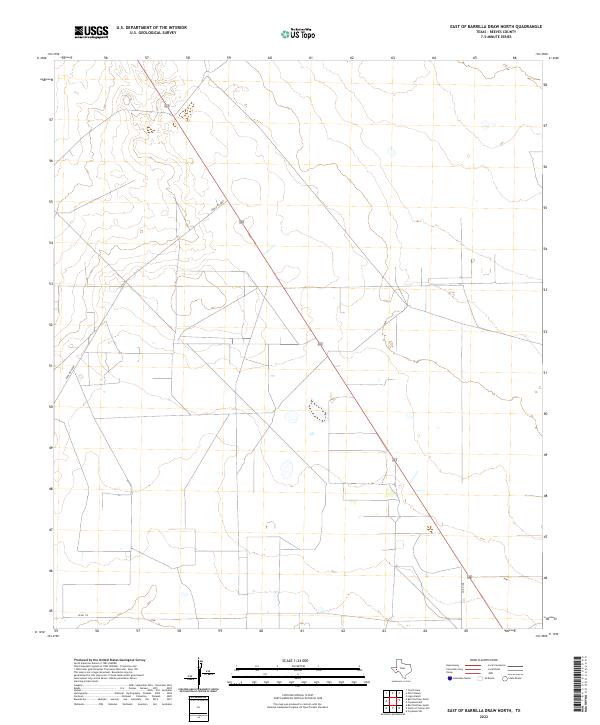
2022 Map of East of Barrilla Draw North
USGS Topo · Published 2022About this map
Ranch Rd 2007 cuts a long diagonal through this arid stretch of Reeves County, serving as the primary corridor for a landscape defined by ranching infrastructure and remote access. The terrain is marked by a network of local thoroughfares, including Co Rd 112 along the southern boundary and Co Rd 108 to the east. This 2022 survey reveals a complex grid of private property boundaries and secondary tracks that support the region's rural economy, where the scarcity of water and natural features is balanced by a meticulously surveyed system of land divisions. The absence of named settlements or major watercourses underscores the specialized, open-range nature of this West Texas territory.
Find a feature on this map
3 named features on this map. Tap any name to fly to it.
Don’t see what you’re looking for? This feature index may not catch every label — zoom into the map to look around manually.
Map Details
Editions of this 2022 East of Barrilla Draw North Map
This is the sole edition of this map. No revisions or reprints were ever made.
Other maps of this area

1931 · Barstow
USGS Topo · 1:125,000

1954 · Pecos
USGS Topo · 1:250,000

1957 · Pecos
USGS Topo · 1:250,000

1963 · Ligon Ranch
USGS Topo · 1:24,000

1963 · Old X Ranch
USGS Topo · 1:24,000

1963 · Toyah Lake
USGS Topo · 1:24,000
1970 · Barstow 3 SW
USGS Topo · 1:24,000
1970 · Barstow 3 SE
USGS Topo · 1:24,000

1970 · Barstow 3 NE
USGS Topo · 1:24,000
1970 · Barstow 3 NW
USGS Topo · 1:24,000