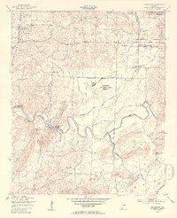
1947 Map of Eastaboga
USGS Topo · Published 1953About this map
The Anniston Air Force Base and the southern reaches of the Anniston Ordnance Depot Military Reservation dominate the landscape of Talladega and Calhoun counties in the years immediately following World War II. The terrain is defined by the winding course of Choccolocco Creek and its tributaries, including Cheaha Creek and Eastaboga Creek. This mid-century survey reveals a rural society centered on small crossroads and faith, with numerous country churches like Kiddstreet Ch, Union Springs Ch, and Craig Memorial Ch dotting the countryside.
Find a feature on this map
24 named features on this map. Tap any name to fly to it.
Don’t see what you’re looking for? This feature index may not catch every label — zoom into the map to look around manually.
Map Details
Editions of this 1947 Eastaboga Map
4 editions found
Other maps of this area

1889 · Springville
USGS Topo · 1:125,000

1890 · Talladega
USGS Topo · 1:125,000

1891 · Ashland
USGS Topo · 1:125,000

1892 · Springville
USGS Topo · 1:125,000

1892 · Talladega
USGS Topo · 1:125,000

1900 · Anniston
USGS Topo · 1:125,000

1943 · Talladega
USGS Topo · 1:62,500

1946 · Talladega
USGS Topo · 1:62,500

1947 · Eastaboga
USGS Topo · 1:24,000

1947 · Ragland
USGS Topo · 1:62,500