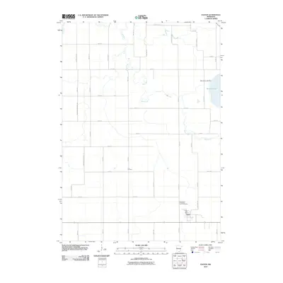
2010 Map of Easton
USGS Topo · Published 2010About this map
The Easton townsite sits at the center of a grid-defined agricultural landscape, serving as a hub for Faribault County during the early 21st century. This survey documents the critical role of water management and civic infrastructure, anchored by the Easton Post Office and the nearby Minnesota Lake Dam. To the east, the waters of Minnesota Lake form a distinct boundary against the surrounding farmland, while the winding course of the Maple River cuts through the northern sections of the township. Local history and genealogy are preserved in sites such as Lura Cemetery and Saint Peter's Evangelical Lutheran Cemetery, which represent the spiritual and ancestral heart of the community. The map's road network, featuring numerous township and county highways, illustrates a landscape designed for efficient transport between rural farmsteads and the central village.
Find a feature on this map
40 named features on this map. Tap any name to fly to it.
Don’t see what you’re looking for? This feature index may not catch every label — zoom into the map to look around manually.
Map Details
Editions of this 2010 Easton Map
This is the sole edition of this map. No revisions or reprints were ever made.
Other maps of this area

1954 · Fairmont
USGS Topo · 1:250,000

1954 · Mason City
USGS Topo · 1:250,000

1955 · Bricelyn
USGS Topo · 1:62,500

1957 · Mason City
USGS Topo · 1:250,000

1958 · Mason City
USGS Topo · 1:250,000

1958 · Fairmont
USGS Topo · 1:250,000

1967 · Minnesota Lake
USGS Topo · 1:24,000
1967 · Mapleton
USGS Topo · 1:24,000
1967 · Easton
USGS Topo · 1:24,000
1967 · Delavan
USGS Topo · 1:24,000