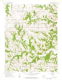
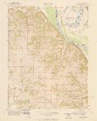
1961 Map of Easton SW
USGS Topo · Published 1962About this map
Alexandria and Union townships define the southeastern landscape of Jefferson County in the early 1960s. This survey illustrates a rural Kansas environment heavily influenced by a network of drainage basins, where Hulls Creek and Walnut Creek carve through the terrain. The map is particularly useful for genealogical research, as it documents specific community centers such as Hebron Ch and Edmonds Ch, along with numerous family and community burial sites. Small tributaries like Buttermilk Creek and Dawson Creek underscore the agricultural nature of the region, where roads often follow the section lines or the natural contours of the winding creek beds. The boundary line between Jefferson Co Leavenworth Co is clearly delineated, marking the edge of these interconnected farming communities.
Find a feature on this map
19 named features on this map. Tap any name to fly to it.
Don’t see what you’re looking for? This feature index may not catch every label — zoom into the map to look around manually.
Map Details
Editions of this 1961 Easton SW Map
3 editions found
Other maps of this area

1886 · Oskaloosa
USGS Topo · 1:125,000

1888 · Oskaloosa
USGS Topo · 1:125,000

1894 · Oskaloosa
USGS Topo · 1:125,000

1948 · Oak Mills
USGS Topo · 1:24,000

1948 · Jarbalo
USGS Topo · 1:24,000

1950 · Kansas City
USGS Topo · 1:250,000

1950 · Easton
USGS Topo · 1:24,000
1950 · Jarbalo
USGS Topo · 1:24,000

1950 · Mc Louth
USGS Topo · 1:24,000
1951 · Oak Mills
USGS Topo · 1:24,000