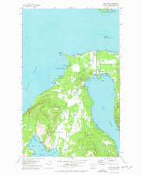
1977 Map of Eastsound
USGS Topo · Published 1978About this map
The northern reaches of Orcas Island are anchored by the community of Eastsound, where the Orcas Island Airport and Orcas Island Sch serve as the central hub between East Sound and West Sound. The landscape is dominated by the dramatic elevations of Turtleback Mountain and Lookout Mtn, while the coastline is dotted with smaller settlements like Beach Haven and Rosario. This 1970s survey captures the island's transition into a premier recreational destination, highlighting numerous protected areas including Sucia Island State Park and Skull Island State Park.
Find a feature on this map
55 named features on this map. Tap any name to fly to it.
Don’t see what you’re looking for? This feature index may not catch every label — zoom into the map to look around manually.
Map Details
Editions of this 1977 Eastsound Map
2 editions found
Other maps of this area

1943 · Orcas Island
USGS Topo · 1:62,500

1954 · Waldron Island
USGS Topo · 1:24,000

1954 · Friday Harbor
USGS Topo · 1:24,000

1957 · Orcas Island
USGS Topo · 1:62,500

1957 · Victoria
USGS Topo · 1:250,000

1973 · Sucia Island
USGS Topo · 1:24,000

1973 · Shaw Island
USGS Topo · 1:24,000
1973 · Blakely Island
USGS Topo · 1:24,000

1975 · Bellingham
USGS Topo · 1:100,000
1978 · Mt Constitution
USGS Topo · 1:24,000