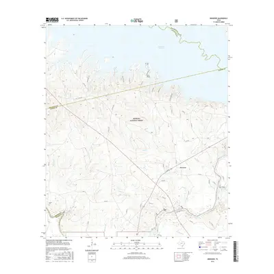
2016 Map of Ebenezer
USGS Topo · Published 2016About this map
The Angelina National Forest dominates this East Texas landscape, where the northern waters of the Sam Rayburn Reservoir meet the intricate drainage system of the Angelina River. The settlement of Ebenezer sits at a crossroads in the eastern portion of the map, serving as a focal point for local history along with residential developments like Crystal River Est. Genealogists will find the Speir Cem near Plum Ridge and Jordan Cem to the southwest, providing specific markers of early family settlement in Jasper County. The terrain is defined by a network of creeks and branches, including Boggy Cr, Buck Br, and Frout Cr, which weave through the timberland. High points such as Concord Hill and the elevated River Ridge overlook the wetlands and sloughs that characterize the river bottom, illustrating the transition from upland forest to riparian basin.
Find a feature on this map
63 named features on this map. Tap any name to fly to it.
Don’t see what you’re looking for? This feature index may not catch every label — zoom into the map to look around manually.
Map Details
Editions of this 2016 Ebenezer Map
This is the sole edition of this map. No revisions or reprints were ever made.
Other maps of this area
1931 · Zavalla
USGS Topo · 1:62,500

1953 · Palestine
USGS Topo · 1:250,000

1954 · Beaumont
USGS Topo · 1:250,000
1955 · Woodville
USGS Topo · 1:62,500
1955 · Curtis
USGS Topo · 1:62,500

1957 · Beaumont
USGS Topo · 1:250,000

1957 · Palestine
USGS Topo · 1:250,000
1958 · Zavalla
USGS Topo · 1:62,500
1958 · Mc Gee Bend
USGS Topo · 1:62,500
1984 · Veach
USGS Topo · 1:24,000