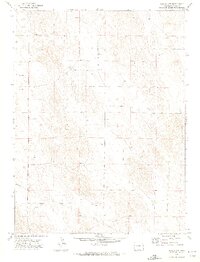
1971 Map of Eckley NW
USGS Topo · Published 1974About this map
Wind-swept plains and rolling sandhills define this 1970s landscape in northeastern Colorado. The map reveals a sparsely populated agricultural environment where section lines and fence lines dictate the spatial organization of the land. Among the few distinctive human marks are a Radio Tower and a large Pipeline cutting diagonally across the southern half of the quadrangle. The terrain itself, including the area labeled Gelvin, is punctuated by numerous depressions and subtle topographic shifts characteristic of the High Plains. While formal towns are absent from this specific sheet, the presence of numerous wells and a clear grid of section boundaries reflects a highly managed ranching and farming economy during the early 1970s.
Find a feature on this map
5 named features on this map. Tap any name to fly to it.
Don’t see what you’re looking for? This feature index may not catch every label — zoom into the map to look around manually.
Map Details
Editions of this 1971 Eckley NW Map
2 editions found
Other maps of this area

1954 · Sterling
USGS Topo · 1:250,000

1958 · Sterling
USGS Topo · 1:250,000

1961 · Eckley
USGS Topo · 1:24,000

1961 · Robb
USGS Topo · 1:24,000

1969 · Schramm
USGS Topo · 1:24,000

1971 · Yuma NE
USGS Topo · 1:24,000

1971 · Wauneta
USGS Topo · 1:24,000

1971 · Eckley NE
USGS Topo · 1:24,000

1971 · Clarkville SE
USGS Topo · 1:24,000

1971 · Old Baldy
USGS Topo · 1:24,000