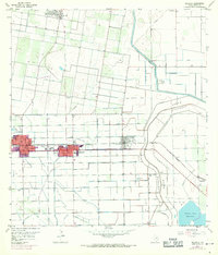
1957 Map of Edcouch
USGS Topo · Published 1970About this map
The agricultural landscape of the Rio Grande Valley takes center stage in this mid-century survey, defined by a complex network of irrigation and flood control. The neighboring towns of Elsa and Edcouch are prominent along the Southern Pacific railroad line, their urban footprints updated in 1970 to show postwar growth. To the east, La Villa sits near the massive North Floodway, a vital engineering feature for regional water management.
Find a feature on this map
26 named features on this map. Tap any name to fly to it.
Don’t see what you’re looking for? This feature index may not catch every label — zoom into the map to look around manually.
Map Details
Editions of this 1957 Edcouch Map
3 editions found
Other maps of this area

1914 · San Juan
USGS Topo · 1:48,000

1916 · San Juan
USGS Topo · 1:62,500

1929 · Santa Rosa
USGS Topo · 1:24,000

1929 · La Feria
USGS Topo · 1:24,000

1933 · Santa Rosa
USGS Topo · 1:31,680

1936 · La Feria
USGS Topo · 1:31,680

1949 · Mc Allen
USGS Topo · 1:250,000

1953 · Brownsville
USGS Topo · 1:250,000

1954 · McAllen
USGS Topo · 1:250,000

1956 · Santa Rosa
USGS Topo · 1:24,000