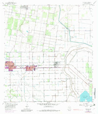
1957 Map of Edcouch
USGS Topo · Published 1982About this map
Agricultural development and water management define the landscape around Edcouch and Elsa during this mid-century period. The region is crisscrossed by an extensive network of irrigation infrastructure, including the Willacy Canal, the Donna Drain, and several sections of Elevated Ditch which sustain the surrounding fields. The Southern Pacific railroad serves as the primary transportation spine connecting these towns, while an Old Railroad Grade north of Monte Alto hints at older transit patterns. Local genealogy is well-represented by distinctive burial grounds such as Cementerio Anahuac, Cementerio de las Burras, and the San Jose Ranch Cemetery. To the south, the economy shifts toward energy and storage, marked by the Lacy-Mercedes Gas Field and the Valley Acres Reservoir. Significant drainage control is evident in the broad path of the North Floodway carving through the eastern territory.
Find a feature on this map
25 named features on this map. Tap any name to fly to it.
Don’t see what you’re looking for? This feature index may not catch every label — zoom into the map to look around manually.
Map Details
Editions of this 1957 Edcouch Map
3 editions found
Other maps of this area

1914 · San Juan
USGS Topo · 1:48,000

1916 · San Juan
USGS Topo · 1:62,500

1929 · Santa Rosa
USGS Topo · 1:24,000

1929 · La Feria
USGS Topo · 1:24,000

1933 · Santa Rosa
USGS Topo · 1:31,680

1936 · La Feria
USGS Topo · 1:31,680

1949 · Mc Allen
USGS Topo · 1:250,000

1953 · Brownsville
USGS Topo · 1:250,000

1954 · McAllen
USGS Topo · 1:250,000

1956 · Santa Rosa
USGS Topo · 1:24,000