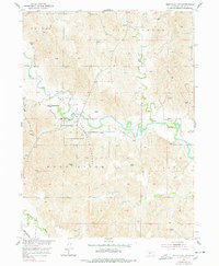
1951 Map of Eddyville NW
USGS Topo · Published 1978About this map
South Loup River meanders across the central portion of this 1951 survey, defining a landscape of agricultural sections and riparian curves in Custer County. The map captures the rural educational infrastructure of the mid-century, preserving the locations of Shiloh Sch, Tuckerville Sch, and Devine Sch along with numerous small windmills scattered across the high ground. Public land use is represented by the Pressy State Recreation Grounds, which borders the river's winding path. In the southwestern corner, the Union Pacific railroad cuts through the valley of the Wood River, illustrating the transport corridor that linked these Nebraska townships to the broader region. The drainage patterns of Ash Creek and Burr Oak Creek further illustrate the topographic character of this prairie country before modern irrigation and development altered the local water table.
Find a feature on this map
13 named features on this map. Tap any name to fly to it.
Don’t see what you’re looking for? This feature index may not catch every label — zoom into the map to look around manually.
Map Details
Editions of this 1951 Eddyville NW Map
3 editions found
Other maps of this area

1951 · Broken Bow SW
USGS Topo · 1:24,000

1951 · Broken Bow SE
USGS Topo · 1:24,000

1951 · Eddyville NE
USGS Topo · 1:24,000

1951 · Callaway SE
USGS Topo · 1:24,000

1951 · Eddyville NW
USGS Topo · 1:24,000

1951 · Oconto SE
USGS Topo · 1:24,000

1951 · Eddyville
USGS Topo · 1:24,000

1951 · Eddyville SW
USGS Topo · 1:24,000

1951 · Oconto
USGS Topo · 1:24,000

1955 · Broken Bow
USGS Topo · 1:250,000