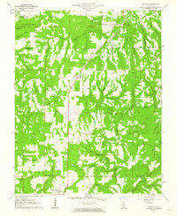
1961 Map of Eddyville
USGS Topo · Published 1962About this map
Shawnee National Forest blankets much of this southern Illinois landscape, where the deeply dissected topography of Stonefort and Independence townships meets. The settlement of Eddyville serves as a southern anchor, while the small community of Delwood sits further north along Route 145. The area is defined by its complex drainage network, including the winding Lusk Creek and Hayes Creek, which have carved notable features like Double Branch Hole and Jackson Hole.
Find a feature on this map
42 named features on this map. Tap any name to fly to it.
Don’t see what you’re looking for? This feature index may not catch every label — zoom into the map to look around manually.
Map Details
Editions of this 1961 Eddyville Map
3 editions found
Other maps of this area

1916 · Golconda
USGS Topo · 1:62,500

1916 · Equality
USGS Topo · 1:62,500

1917 · Brownfield
USGS Topo · 1:62,500

1920 · Goloonda
USGS Topo · 1:48,000

1921 · Golconda
USGS Topo · 1:62,500

1925 · Harrisburg
USGS Topo · 1:62,500

1939 · Harrisburg
USGS Topo · 1:62,500

1949 · Paducah
USGS Topo · 1:250,000

1950 · Paducah
USGS Topo · 1:250,000

1954 · Paducah
USGS Topo · 1:250,000