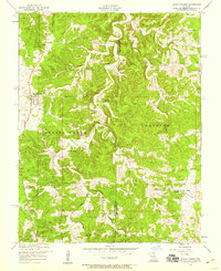
1954 Map of Edgar Springs
USGS Topo · Published 1959About this map
Edgar Springs and the surrounding rural uplands of the Missouri Ozarks are documented here during the mid-1950s. The landscape is defined by the winding course of Little Piney Creek and its many tributaries, including Jackson Branch and Solomon Hollow. This era reveals a community closely tied to its local institutions, with small social centers like the Freeman Store and numerous country schools such as Mt Tabor School and Black Oak School scattered across the township boundaries of Spring Creek and Watkins.
Find a feature on this map
28 named features on this map. Tap any name to fly to it.
Don’t see what you’re looking for? This feature index may not catch every label — zoom into the map to look around manually.
Map Details
Editions of this 1954 Edgar Springs Map
2 editions found
Other maps of this area

1912 · Rolla
USGS Topo · 1:62,500

1928 · Meramec Spring
USGS Topo · 1:62,500

1937 · Edgar Springs
USGS Topo · 1:48,000

1941 · Salem
USGS Topo · 1:62,500

1945 · Salem
USGS Topo · 1:62,500

1945 · Edgar Springs
USGS Topo · 1:62,500

1949 · Rolla
USGS Topo · 1:250,000

1949 · Meramec Spring
USGS Topo · 1:62,500
1950 · Kaintuck Hollow
USGS Topo · 1:24,000
1950 · Yancy Mills
USGS Topo · 1:24,000