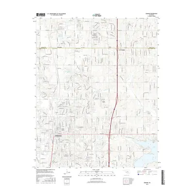
2016 Map of Edmond
USGS Topo · Published 2016About this map
The Univ of Central Oklahoma anchors the southern landscape of this 2016 survey, reflecting the established educational and suburban character of the region. This area, spanning the border of Logan and Oklahoma counties, shows a transition from the denser residential blocks of Edmond to the north toward Guthrie and the smaller community of Waterloo. Significant local landmarks include Edmond Airport and Myrick Airport, alongside recreational and water management features like Lake Arcadia and the Cottonwood Creek Site 54 Reservoir. For genealogists and local historians, several burial grounds are detailed, including Waterloo Cem, Gracelawn Cem, Oakwood Cem, and Pleasant Hill Cem. The inclusion of the Acadia Lake Multi-Use Trail and the grid-to-watershed pattern of Coffee Cr and Crystal Creek highlights the blend of modern infrastructure and natural drainage.
Find a feature on this map
34 named features on this map. Tap any name to fly to it.
Don’t see what you’re looking for? This feature index may not catch every label — zoom into the map to look around manually.
Map Details
Editions of this 2016 Edmond Map
This is the sole edition of this map. No revisions or reprints were ever made.
Other maps of this area

1892 · Guthrie
USGS Topo · 1:62,500

1892 · Edmond
USGS Topo · 1:62,500

1892 · Kingfisher
USGS Topo · 1:125,000

1895 · Kingfisher
USGS Topo · 1:125,000

1935 · Spencer
USGS Topo · 1:24,000

1935 · Edmond
USGS Topo · 1:48,000

1940 · Edmond
USGS Topo · 1:62,500

1951 · Britton
USGS Topo · 1:24,000

1954 · Oklahoma City
USGS Topo · 1:250,000
1955 · Jones
USGS Topo · 1:24,000