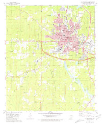
1981 Map of El Dorado West
USGS Topo · Published 1981About this map
El Dorado stands as a significant industrial and educational hub in South Arkansas, dominated by the sprawling infrastructure of the South El Dorado Oil Field and the Nick Springs Oil Field. The landscape is a dense network of petroleum production, featuring a massive Tank Farm, a Refinery, and a complex web of pipelines. This industrial footprint is balanced by institutional growth, notably the Southern Arkansas Univ (El Dorado Branch) and the South Arkansas Arboretum (West High Sch). Away from the city center, the terrain transitions into the wetlands of Bayou de Loutre, where numerous small churches and cemeteries like Old Parkers Chapel Cem and Hickory Grove Chapel suggest older patterns of rural settlement. The presence of the Downtown Airport and several local schools like Hugh Goodwin Sch underscores the area's mid-century modernization.
Find a feature on this map
66 named features on this map. Tap any name to fly to it.
Don’t see what you’re looking for? This feature index may not catch every label — zoom into the map to look around manually.
Map Details
Editions of this 1981 El Dorado West Map
2 editions found
Other maps of this area

1927 · El Dorado
USGS Topo · 1:62,500

1930 · El Dorado
USGS Topo · 1:62,500

1951 · El Dorado
USGS Topo · 1:62,500

1953 · El Dorado
USGS Topo · 1:250,000

1957 · El Dorado
USGS Topo · 1:250,000

1958 · El Dorado
USGS Topo · 1:250,000

1960 · El Dorado
USGS Topo · 1:250,000

1962 · Lisbon
USGS Topo · 1:24,000

1962 · Smackover
USGS Topo · 1:24,000
1962 · Calion
USGS Topo · 1:24,000