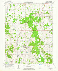
1961 Map of Elberfeld
USGS Topo · Published 1963About this map
The town of Elberfeld serves as the focal point of this 1961 survey, situated at the intersection of early industrial and agricultural corridors. The landscape is notably marked by the historical alignment of the Erie and Wabash Canal, which sits near modern rail lines of the New York Central. Substantial coal and energy extraction is evident through the Elberfeld Mine and numerous Oil Wells scattered across the northern sections near Buckskin.
Find a feature on this map
49 named features on this map. Tap any name to fly to it.
Don’t see what you’re looking for? This feature index may not catch every label — zoom into the map to look around manually.
Map Details
Editions of this 1961 Elberfeld Map
4 editions found
Other maps of this area

1901 · Princeton
USGS Topo · 1:62,500

1901 · Haubstadt
USGS Topo · 1:62,500

1902 · Ditney
USGS Topo · 1:125,000

1902 · Boonville
USGS Topo · 1:62,500

1903 · Haubstadt
USGS Topo · 1:62,500

1903 · Petersburg
USGS Topo · 1:62,500

1903 · Princeton
USGS Topo · 1:62,500

1903 · Patoka
USGS Topo · 1:125,000

1956 · Vincennes
USGS Topo · 1:250,000

1957 · Vincennes
USGS Topo · 1:250,000