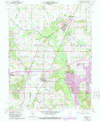
1961 Map of Elberfeld
USGS Topo · Published 1989About this map
Elberfeld and its surroundings at the junction of Gibson, Warrick, and Vanderburgh Counties reveal a landscape defined by coal extraction and drainage engineering. The presence of the Elberfeld Mine south of town underscores the region's industrial base, while the remnants of the Wabash and Erie Canal near Buckskin trace an older era of mid-19th-century transport. The terrain is marked by family and community landmarks, such as Susott Cem, Northview Cem, and Nobles Chapel, which anchor the rural crossroads of Greer and Johnson townships.
Find a feature on this map
50 named features on this map. Tap any name to fly to it.
Don’t see what you’re looking for? This feature index may not catch every label — zoom into the map to look around manually.
Map Details
Editions of this 1961 Elberfeld Map
4 editions found
Other maps of this area

1901 · Princeton
USGS Topo · 1:62,500

1901 · Haubstadt
USGS Topo · 1:62,500

1902 · Ditney
USGS Topo · 1:125,000

1902 · Boonville
USGS Topo · 1:62,500

1903 · Haubstadt
USGS Topo · 1:62,500

1903 · Petersburg
USGS Topo · 1:62,500

1903 · Princeton
USGS Topo · 1:62,500

1903 · Patoka
USGS Topo · 1:125,000

1956 · Vincennes
USGS Topo · 1:250,000

1957 · Vincennes
USGS Topo · 1:250,000