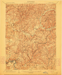
1904 Map of Elders Ridge
USGS Topo · Published 1912About this map
Cochran Mills and Brick Church anchor a landscape of deeply incised stream valleys at the dawn of the twentieth century. This survey documents a critical period of industrial transition where traditional water-powered sites like Cochran Mills along Crooked Creek coexist with the expanding mineral and rail economy. The southern reaches of the map are defined by the winding Kiskiminetas River, serving as a natural boundary for Westmoreland Co, while the Buffalo Rochester and Pittsburg RR cuts through the eastern hills near Parkwood. Notable for genealogists, the map identifies small post offices and hamlets like Long Run P.O. and Maysville, many of which served the scattered farms and early mining operations of the Armstrong Co and Indiana Co borderlands. The intricate drainage network, from Blacklegs Creek to Plum Creek, reveals the topographic challenges faced by early road builders along the Pittsburg and Rochester Road.
Find a feature on this map
80 named features on this map. Tap any name to fly to it.
Don’t see what you’re looking for? This feature index may not catch every label — zoom into the map to look around manually.
Map Details
Editions of this 1904 Elders Ridge Map
5 editions found
Other maps of this area

1900 · Latrobe
USGS Topo · 1:62,500

1900 · Kittanning
USGS Topo · 1:62,500

1901 · Rural Valley
USGS Topo · 1:62,500

1902 · Kittanning
USGS Topo · 1:62,500

1902 · Latrobe
USGS Topo · 1:62,500

1902 · Indiana
USGS Topo · 1:62,500

1902 · Elders Ridge
USGS Topo · 1:62,500

1903 · Rural Valley
USGS Topo · 1:62,500

1903 · Latrobe
USGS Topo · 1:62,500

1904 · Elders Ridge
USGS Topo · 1:62,500