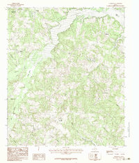
1983 Map of Elderville
USGS Topo · Published 1983About this map
Cherokee Lake dominates the upper central landscape of this East Texas region, straddling the Gregg Co Rusk Co line during the early 1980s. The area is defined by a dense network of tributaries and minor drainages, including the Tiawichi Creek and Beaver Marsh Creek, which feed into the primary reservoir system. Small rural settlements and family-named locales like Elderville, Chalk Hill, and Oak Hill are scattered throughout the wooded terrain, connected by a web of unimproved roads and local trails that speak to the quiet, residential character of the county during this period.
Find a feature on this map
28 named features on this map. Tap any name to fly to it.
Don’t see what you’re looking for? This feature index may not catch every label — zoom into the map to look around manually.
Map Details
Editions of this 1983 Elderville Map
2 editions found
Other maps of this area

1935 · Henderson
USGS Topo · 1:48,000

1936 · Kilgore
USGS Topo · 1:48,000

1939 · Henderson
USGS Topo · 1:62,500

1940 · Kilgore
USGS Topo · 1:62,500

1956 · Tyler
USGS Topo · 1:250,000

1958 · Tatum
USGS Topo · 1:62,500

1960 · Minden
USGS Topo · 1:62,500

1971 · Kilgore NE
USGS Topo · 1:24,000
1971 · Kilgore SE
USGS Topo · 1:24,000

1973 · Henderson
USGS Topo · 1:24,000