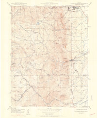
1942 Map of Eldorado Springs
USGS Topo · Published 1942About this map
South Boulder Creek cuts through the dramatic vertical relief of the Front Range in this 1942 survey, where the Denver and Salt Lake railroad winds through the mountains toward the Crescent Mountain and Blue Mountain summits. The map reveals a transition from the established outskirts of Boulder, marked by the Green Mountain Cemetery and the Chautauqua grounds, to the industrial and agricultural pockets of the high country. Resource extraction and transit define the landscape, from the Copeland Mine near Winiger Ridge to the rural Coal Creek Store and the scattered homes of Magnolia. Educational sites like the Pine Grove Sch (abandoned) and Plainview Sch reflect the changing demographics of these mountain communities during the early war years, while the Walker Ranch and Kossler Ranch represent the enduring presence of high-altitude livestock operations.
Find a feature on this map
60 named features on this map. Tap any name to fly to it.
Don’t see what you’re looking for? This feature index may not catch every label — zoom into the map to look around manually.
Map Details
Editions of this 1942 Eldorado Springs Map
4 editions found
Other maps of this area

1899 · West Denver
USGS Topo · 1:125,000

1902 · Boulder
USGS Topo · 1:62,500

1904 · Niwot
USGS Topo · 1:62,500

1904 · Boulder
USGS Topo · 1:62,500

1906 · Blackhawk
USGS Topo · 1:62,500

1939 · Golden
USGS Topo · 1:24,000

1942 · Eldorado Springs
USGS Topo · 1:24,000

1942 · Golden
USGS Topo · 1:31,680

1942 · Louisville
USGS Topo · 1:31,680

1942 · Tungsten
USGS Topo · 1:24,000