
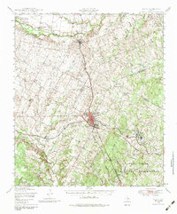
1948 Map of Elgin
USGS Topo · Published 1969About this map
The sprawling Camp Swift Military Reservation anchors the southern landscape of this Central Texas region during the late 1940s, a time when the area was defined by a complex intersection of county lines and rail corridors. The Missouri Kansas & Texas RR and Southern Pacific RR converge at Elgin, facilitating a transit network that connected rural outposts like Coupland and Littig to larger markets.
Find a feature on this map
55 named features on this map. Tap any name to fly to it.
Don’t see what you’re looking for? This feature index may not catch every label — zoom into the map to look around manually.
Map Details
Editions of this 1948 Elgin Map
2 editions found
Other maps of this area

1885 · Taylor
USGS Topo · 1:125,000

1885 · Bastrop
USGS Topo · 1:125,000

1887 · Taylor
USGS Topo · 1:125,000

1893 · Georgetown
USGS Topo · 1:125,000

1893 · Bastrop
USGS Topo · 1:125,000

1894 · Taylor
USGS Topo · 1:125,000

1896 · Austin
USGS Topo · 1:125,000

1897 · Austin
USGS Topo · 1:125,000

1904 · Bastrop
USGS Topo · 1:125,000

1910 · Austin
USGS Topo · 1:125,000