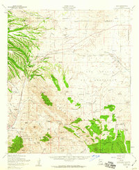
1958 Map of Elgin
USGS Topo · Published 1959About this map
San Ignacio del Babocomari land grant territory anchors this mid-century look at the ranching and mining country of the high desert. The survey highlights the significant military history of the region by marking the former locations of Fort Crittenden and Fort Buchanan near the confluence of Sonoita Creek. Local ranching life is well-documented through numerous named family properties like Hacienda Los Encinos, Stoddard Ranch, and Crown C Ranch. Transportation is defined by the Southern Pacific railroad corridor, which connects the settlements of Sonoita, Elgin, and Patagonia. The southern portion of the map reveals the area's extraction history at the Christmas Gift Mine and Elevation Group Mines within the Coronado National Forest, where the terrain rises toward peaks like North Saddle Mtn and Candelaria Peak.
Find a feature on this map
101 named features on this map. Tap any name to fly to it.
Don’t see what you’re looking for? This feature index may not catch every label — zoom into the map to look around manually.
Map Details
Editions of this 1958 Elgin Map
3 editions found
Other maps of this area

1904 · Patagonia
USGS Topo · 1:125,000

1905 · Patagonia
USGS Topo · 1:125,000

1905 · Nogales
USGS Topo · 1:125,000

1914 · Hereford
USGS Topo · 1:125,000

1915 · Benson
USGS Topo · 1:125,000

1922 · Agus Caliente
USGS Topo · 1:62,500

1922 · Sunnyside
USGS Topo · 1:62,500

1926 · Whetstone
USGS Topo · 1:62,500

1926 · Helvetia
USGS Topo · 1:62,500

1932 · Lochiel
USGS Topo · 1:62,500