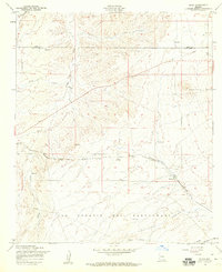
1958 Map of Elgin
USGS Topo · Published 1959About this map
Elgin serves as a central point of reference in this late 1950s survey of the high desert grasslands where Santa Cruz and Pima counties meet. The settlement is positioned along the Southern Pacific railroad line, which cuts a sharp diagonal through the landscape. The surrounding area is characterized by an extensive network of drainages and canyons, including Cienega Creek, Gardner Canyon, and Smith Canyon. To the east, the Mustang Mts rise above the basin, while the southern portion of the map is defined by the San Ignacio Del Babocomari grant and the Babocomari River.
Find a feature on this map
25 named features on this map. Tap any name to fly to it.
Don’t see what you’re looking for? This feature index may not catch every label — zoom into the map to look around manually.
Map Details
Editions of this 1958 Elgin Map
4 editions found
Other maps of this area

1904 · Patagonia
USGS Topo · 1:125,000

1905 · Patagonia
USGS Topo · 1:125,000

1915 · Benson
USGS Topo · 1:125,000

1926 · Whetstone
USGS Topo · 1:62,500

1932 · Elgin
USGS Topo · 1:62,500

1938 · Huachuca
USGS Topo · 1:62,500

1940 · Elgin
USGS Topo · 1:62,500

1943 · Benson
USGS Topo · 1:125,000

1947 · Elgin
USGS Topo · 1:62,500

1948 · Elgin
USGS Topo · 1:24,000