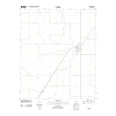
2010 Map of Elida
USGS Topo · Published 2010About this map
The high plains of Roosevelt County are anchored here by the village of Elida, showing a landscape defined by a rigid section-line grid of rural routes. The town site itself is concentrated at the intersection of local thoroughfares like Travis St and major regional corridors. Significant local history markers include the Elida Cemetery and the Elida Post Office, which serve as the community's civic heart. The natural topography is subtly marked by Boone Draw, an intermittent drainage feature that cuts across the geometric road network, including S Roosevelt Road 18 and S Roosevelt Road 25. This survey reflects the enduring cattle-country character of eastern New Mexico, where the infrastructure remains largely tied to agricultural access and the modest footprints of early 20th-century settlements.
Find a feature on this map
16 named features on this map. Tap any name to fly to it.
Don’t see what you’re looking for? This feature index may not catch every label — zoom into the map to look around manually.
Map Details
Editions of this 2010 Elida Map
This is the sole edition of this map. No revisions or reprints were ever made.
Other maps of this area

1954 · Clovis
USGS Topo · 1:250,000

1954 · Brownfield
USGS Topo · 1:250,000

1958 · Brownfield
USGS Topo · 1:250,000

1958 · Clovis
USGS Topo · 1:250,000

1962 · Brownfield
USGS Topo · 1:250,000

1973 · Lewiston Lake
USGS Topo · 1:24,000

1973 · Gammil Well SE
USGS Topo · 1:24,000

1973 · Floyd SE
USGS Topo · 1:24,000
1978 · Elida
USGS Topo · 1:24,000
1979 · Badger Lake
USGS Topo · 1:24,000