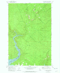
1969 Map of Elk Creek Falls
USGS Topo · Published 1982About this map
Dworshak Reservoir dominates the lower landscape of this 1969 survey, illustrating the significant hydrological transformation of the Elk Creek drainage. The map records the area just as the reservoir began to fill, following the construction of the Dworshak Dam. Higher elevations are marked by a network of drainage systems and prominent landforms like Tick Ridge and Aldermand Ridge. A series of natural cataracts, including Elk Creek Falls and Bull Run Creek Falls, remain central landmarks in this timber-rich portion of Clearwater County. Evidence of recreation and small-scale settlement appears at the Elk Creek Picnic Area (Camp Y) and Twin Springs, while Five Corners serves as a key junction for the local Jeep Trail network. The inclusion of a Gravel Pit reflects the infrastructure needs of the era, supporting the roads that navigate this complex drainage basin before the landscape was fully altered by rising waters.
Find a feature on this map
23 named features on this map. Tap any name to fly to it.
Don’t see what you’re looking for? This feature index may not catch every label — zoom into the map to look around manually.
Map Details
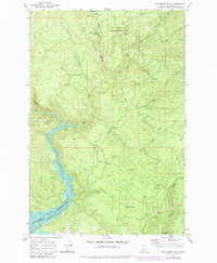
Editions of this 1969 Elk Creek Falls Map
3 editions found
Other maps of this area

1955 · Pullman
USGS Topo · 1:250,000

1958 · Pullman
USGS Topo · 1:250,000

1961 · Ahsahka
USGS Topo · 1:62,500

1961 · Bovill
USGS Topo · 1:62,500

1969 · Elk River
USGS Topo · 1:24,000

1969 · Elk Creek Falls
USGS Topo · 1:24,000
1969 · Grangemont
USGS Topo · 1:24,000
1969 · Dent
USGS Topo · 1:24,000
1969 · Elk Butte
USGS Topo · 1:24,000
1969 · Little Green Mountain
USGS Topo · 1:24,000