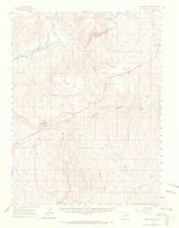
1960 Map of Elk Springs
USGS Topo · Published 1969About this map
Cross Mountain and the deep cut of Cross Mountain Canyon dominate this high-desert landscape in northwestern Colorado. The Yampa River winds through the northern portion of the map, joining with the Little Snake River near several established cattle operations, including the Rinker Ranch, Tuttle Ranch, and White Bear Ranch. These family-named landmarks, clustered near Lily Park, reflect the ranching history of the region where water access dictated the placement of permanent settlements. Further south, the map details the terrain of Twelvemile Mesa and the Pinyon Ridge, which are bisected by numerous drainage systems like Wolf Creek and Sagebrush Creek. The small community of Elk Springs sits along the Bear Valley Road, serving as a central point for the remote ranches and gas wells scattered across the sagebrush-covered draws and washes.
Find a feature on this map
34 named features on this map. Tap any name to fly to it.
Don’t see what you’re looking for? This feature index may not catch every label — zoom into the map to look around manually.
Map Details
Editions of this 1960 Elk Springs Map
4 editions found
Other maps of this area

1907 · Rangely
USGS Topo · 1:125,000

1907 · White River
USGS Topo · 1:125,000

1910 · White River
USGS Topo · 1:125,000

1910 · Rangely
USGS Topo · 1:125,000

1954 · Vernal
USGS Topo · 1:250,000

1958 · Vernal
USGS Topo · 1:250,000

1958 · Maybell
USGS Topo · 1:62,500

1958 · Citadel Plateau
USGS Topo · 1:62,500

1960 · Vernal
USGS Topo · 1:250,000

1960 · Elk Springs
USGS Topo · 1:62,500