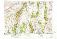
1958 Map of Elko
USGS Topo · Published 1958About this map
Elko serves as the primary hub along the Humboldt River in this mid-century survey of northeastern Nevada and western Utah. The landscape is dominated by the massive north-south orientation of the Ruby Mountains and Pequop Mountains, creating a sequence of distinct basins including Ruby Valley and Goshute Valley. The transportation corridor is defined by the parallel tracks of the Southern Pacific and Western Pacific railroads, which navigate through high-desert passes and past remote outposts like Tobar and Shafter.
Find a feature on this map
127 named features on this map. Tap any name to fly to it.
Don’t see what you’re looking for? This feature index may not catch every label — zoom into the map to look around manually.
Map Details
Editions of this 1958 Elko Map
2 editions found

Other maps of this area

1908 · Fish Springs
USGS Topo · 1:250,000

1910 · Fish Springs
USGS Topo · 1:250,000

1925 · Gold Hill
USGS Topo · 1:62,500

1926 · Roberts Mountains
USGS Topo · 1:250,000

1928 · Gold Hill
USGS Topo · 1:62,500

1929 · Roberts Mountains
USGS Topo · 1:250,000

1934 · Jiggs
USGS Topo · 1:125,000

1935 · Halleck
USGS Topo · 1:125,000

1937 · Mineral Hill
USGS Topo · 1:48,000

1937 · Jiggs
USGS Topo · 1:125,000