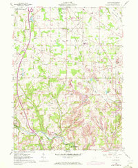
1960 Map of Elkton
USGS Topo · Published 1960About this map
Elkton and the surrounding townships of Fairfield and Elkrun are defined by a complex network of resource extraction and transit corridors. The landscape is heavily marked by Strip Mines that follow the contours of the drainage basins, particularly near Middle Run and Bull Creek. These industrial sites contrast with the established community structures of the early 1960s, including Middleton High Sch and several remote burying grounds like Church Hill Cem and Kembles Cem.
Find a feature on this map
53 named features on this map. Tap any name to fly to it.
Don’t see what you’re looking for? This feature index may not catch every label — zoom into the map to look around manually.
Map Details
Editions of this 1960 Elkton Map
2 editions found
Other maps of this area

1904 · Wellsville
USGS Topo · 1:62,500

1905 · Salineville
USGS Topo · 1:62,500

1907 · Columbiana
USGS Topo · 1:62,500

1909 · Lisbon
USGS Topo · 1:62,500

1909 · Columbiana
USGS Topo · 1:62,500

1937 · Wellsville
USGS Topo · 1:62,500

1944 · Wellsville
USGS Topo · 1:62,500

1951 · Canton
USGS Topo · 1:250,000

1951 · Columbiana
USGS Topo · 1:24,000
1951 · New Middletown
USGS Topo · 1:24,000