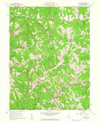
1961 Map of Ellenboro
USGS Topo · Published 1962About this map
The Baltimore and Ohio railroad corridor anchors this early 1960s study of the Ritchie County landscape, following the winding path of Bonds Creek through the rugged Appalachian terrain. The town of Ellenboro and the nearby settlement of Lamberton serve as the primary hubs in a region defined by narrow valleys and steep ridges like Pigskin Ridge. The map reveals a highly dispersed settlement pattern, where small communities such as Pike, Finch, and Adlai are often centered around local landmarks like Mt Zion Church or Mt Olivet Church. Numerous gas wells are scattered throughout the hills, particularly along the branches of McKim Creek and French Creek, documenting the active energy extraction economy of the mid-twentieth century. This survey provides a clear view of the rural infrastructure before modern highway expansions, capturing the network of secondary roads and local churches that defined West Virginia country life in this era.
Find a feature on this map
54 named features on this map. Tap any name to fly to it.
Don’t see what you’re looking for? This feature index may not catch every label — zoom into the map to look around manually.
Map Details
Editions of this 1961 Ellenboro Map
3 editions found
Other maps of this area

1905 · West Union
USGS Topo · 1:62,500

1906 · Saint Marys
USGS Topo · 1:62,500

1906 · Holbrook
USGS Topo · 1:62,500

1907 · Harrisville
USGS Topo · 1:62,500

1924 · St Marys
USGS Topo · 1:62,500

1924 · Harrisville
USGS Topo · 1:62,500

1924 · West Union
USGS Topo · 1:62,500

1924 · Holbrook
USGS Topo · 1:62,500

1926 · Harrisville
USGS Topo · 1:62,500

1926 · Holbrook
USGS Topo · 1:62,500