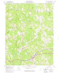
1961 Map of Ellenboro
USGS Topo · Published 1977About this map
Ellenboro and the neighboring community of Lamberton anchor the southern reaches of this landscape, situated along the critical transit corridor of the Baltimore and Ohio railroad. The terrain is defined by a dense network of narrow runs and hollows, such as Church Hollow and Brooks Hollow, which dictated the placement of early settlements and family-named landmarks. Numerous country churches, including Ninemile Ch, Mt Zion Ch, and Mt Olivet Ch, serve as focal points for rural life throughout Grant, Clay, and Lafayette districts.
Find a feature on this map
61 named features on this map. Tap any name to fly to it.
Don’t see what you’re looking for? This feature index may not catch every label — zoom into the map to look around manually.
Map Details
Editions of this 1961 Ellenboro Map
3 editions found
Other maps of this area

1905 · West Union
USGS Topo · 1:62,500

1906 · Saint Marys
USGS Topo · 1:62,500

1906 · Holbrook
USGS Topo · 1:62,500

1907 · Harrisville
USGS Topo · 1:62,500

1924 · St Marys
USGS Topo · 1:62,500

1924 · Harrisville
USGS Topo · 1:62,500

1924 · West Union
USGS Topo · 1:62,500

1924 · Holbrook
USGS Topo · 1:62,500

1926 · Harrisville
USGS Topo · 1:62,500

1926 · Holbrook
USGS Topo · 1:62,500