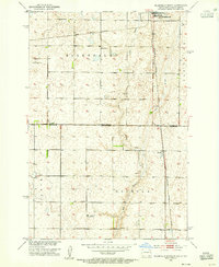
1953 Map of Ellendale South
USGS Topo · Published 1955About this map
Ellendale anchors the northern edge of this mid-century survey, which documents the rural landscape straddling the North Dakota-South Dakota border. The township divisions of Palmyra, Ellendale, and Osceola organize a prairie terrain marked by ephemeral watercourses like Dry Branch and scattered Gravel Pits. The regional transport economy is defined by the Chicago Milwaukee St Paul and Pacific railroad, which runs south past the small settlement of Winship. Local education and community nodes are prominent, with School No 16, Gustafson Sch, and Senn Sch serving the surrounding homesteads. This map illustrates the intersection of Dickey and Brown counties, capturing a period when one-room schoolhouses and remote rail sidings remained essential to the Dakota grain-belt infrastructure.
Find a feature on this map
17 named features on this map. Tap any name to fly to it.
Don’t see what you’re looking for? This feature index may not catch every label — zoom into the map to look around manually.
Map Details
Editions of this 1953 Ellendale South Map

Other maps of this area

1894 · Monango
USGS Topo · 1:62,500

1894 · Ellendale
USGS Topo · 1:62,500

1894 · Savo
USGS Topo · 1:62,500

1894 · Fullerton
USGS Topo · 1:62,500

1895 · Lamoure
USGS Topo · 1:125,000

1896 · Columbia
USGS Topo · 1:125,000

1896 · Edgeley
USGS Topo · 1:125,000

1899 · Ellendale
USGS Topo · 1:125,000

1918 · La Moure
USGS Topo · 1:125,000

1925 · Edgeley
USGS Topo · 1:125,000