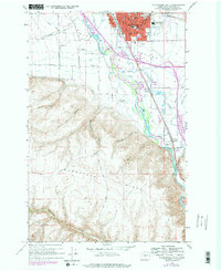
1958 Map of Ellensburg South
USGS Topo · Published 1978About this map
Ellensburg serves as the focal point of this 1950s survey, updated in the late 1970s to reflect the expanding infrastructure of the Kittitas Valley. The map details the transition from the structured city grid—anchored by landmarks like the Courthouse and several local institutions including Lincoln Sch and Washington School—to the steep elevations of Manastash Ridge and Umtanum Ridge. The Yakima River snakes through the center of the quadrangle, flanked by agricultural irrigation works such as Tjossem Ditch and the Naneum Creek drainage. Transportation corridors are well-defined, showing the paths of the Burlington Northern and Chicago Milwaukee St Paul & Pacific railroads. Rural life is evidenced by small settlements like Thrall and Holmes, alongside the outlying Dammon School, illustrating the distribution of the valley’s mid-century population before modern development intensified.
Find a feature on this map
47 named features on this map. Tap any name to fly to it.
Don’t see what you’re looking for? This feature index may not catch every label — zoom into the map to look around manually.
Map Details
Editions of this 1958 Ellensburg South Map
4 editions found
Other maps of this area

1897 · Mount Stuart
USGS Topo · 1:125,000

1899 · Ellensburg
USGS Topo · 1:125,000

1901 · Ellensburg
USGS Topo · 1:125,000

1902 · Mount Stuart
USGS Topo · 1:125,000

1920 · Colockum Pass
USGS Topo · 1:125,000

1922 · Colockum Pass
USGS Topo · 1:125,000

1938 · Badger Pocket
USGS Topo · 1:48,000

1943 · Badger Pocket
USGS Topo · 1:62,500

1950 · Yakima
USGS Topo · 1:250,000

1953 · Kittitas
USGS Topo · 1:24,000