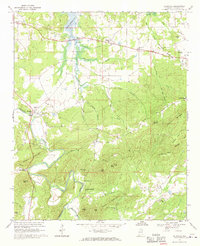
1967 Map of Ellisville
USGS Topo · Published 1970About this map
Terrapin Creek and the Weiss Reservoir dominate the landscape of Cherokee County in the late 1960s, a period when the local economy balanced rural agriculture with emerging industrial sites like the sandpit near Ellisville. This map documents the transition from older communities like Old Coloma to newer shoreline developments. The interior is dotted with landmark heights such as Frog Mountain and McCauley Mountain, while the valleys are anchored by long-standing rural institutions. For genealogists, the map is a detailed guide to local heritage, locating several country churches including Jennings Chapel and Mt Zion Ch, alongside the Hebron Ch Cem. The presence of the Lebanon Campground and the Gaging Sta on the creek reflects the area's dual focus on recreation and water management following the reservoir's creation.
Find a feature on this map
54 named features on this map. Tap any name to fly to it.
Don’t see what you’re looking for? This feature index may not catch every label — zoom into the map to look around manually.
Map Details
Editions of this 1967 Ellisville Map
2 editions found
Other maps of this area

1886 · Rome
USGS Topo · 1:125,000

1889 · Tallapoosa
USGS Topo · 1:125,000

1892 · Tallapoosa
USGS Topo · 1:125,000

1893 · Fort Payne
USGS Topo · 1:125,000

1897 · Tallapoosa
USGS Topo · 1:125,000

1898 · Rome
USGS Topo · 1:125,000

1898 · Fort Payne
USGS Topo · 1:125,000

1899 · Rome
USGS Topo · 1:125,000

1900 · Fort Payne
USGS Topo · 1:125,000

1900 · Anniston
USGS Topo · 1:125,000