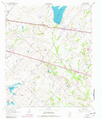
1962 Map of Elmo
USGS Topo · Published 1982About this map
New Terrell City Lake and its prominent spillway dominate the northern landscape of this Kaufman County region, serving as a focal point for local water management and recreation. The Texas and Pacific railroad corridor serves as the primary East-West axis, anchoring the community of Elmo and its nearby Roadside Park. This area of Texas transitioned through the mid-20th century from a purely agrarian landscape toward more integrated infrastructure, evidenced by the Filtration Plant and various pipelines traversing the terrain. Rural life is well-documented through scattered landmarks such as Fairview Ch, Shady Grove Ch, and the small settlement at Hiram. To the south, the topography rises toward College Mound, while numerous waterways like Muddy Cedar Creek and Eagans Branch define the natural drainage patterns of the countryside. Smaller locales like Abner and a remote Landing Strip illustrate the diverse land use of the era.
Find a feature on this map
27 named features on this map. Tap any name to fly to it.
Don’t see what you’re looking for? This feature index may not catch every label — zoom into the map to look around manually.
Map Details
Editions of this 1962 Elmo Map
2 editions found
Other maps of this area

1919 · Royse City
USGS Topo · 1:62,500

1954 · Dallas
USGS Topo · 1:250,000

1956 · Kaufman
USGS Topo · 1:62,500

1956 · Quinlan
USGS Topo · 1:62,500

1958 · Dallas
USGS Topo · 1:250,000

1962 · Elmo
USGS Topo · 1:24,000

1962 · Cedarvale
USGS Topo · 1:24,000

1962 · Wills Point
USGS Topo · 1:24,000
1962 · Ola
USGS Topo · 1:24,000
1962 · Terrell North
USGS Topo · 1:24,000