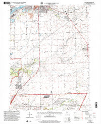
1999 Map of Elwood
USGS Topo · Published 2002About this map
The Abraham Lincoln National Cemetery and the sprawling Midewin National Tallgrass Prairie dominate the southern portion of this landscape, reflecting a major transition of former industrial and military lands into protected public space. This territory, once part of the Joliet Army Ammunition Plant, is bordered by the Joliet Training Area and a heavily utilized section of the Dept of Army facility. The Elgin Joliet and Eastern RR cuts through the region, connecting the village of Elwood with the neighboring settlement of Manhattan to the east.
Find a feature on this map
46 named features on this map. Tap any name to fly to it.
Don’t see what you’re looking for? This feature index may not catch every label — zoom into the map to look around manually.
Map Details
Editions of this 1999 Elwood Map
This is the sole edition of this map. No revisions or reprints were ever made.
Other maps of this area

1890 · Des Plaines
USGS Topo · 1:62,500

1892 · Joliet
USGS Topo · 1:62,500

1892 · Wilmington
USGS Topo · 1:62,500

1894 · Des Plaines
USGS Topo · 1:62,500

1900 · Des Plaines
USGS Topo · 1:62,500

1901 · Des Plaines
USGS Topo · 1:62,500

1918 · Wilmington
USGS Topo · 1:62,500

1923 · Joliet
USGS Topo · 1:62,500

1929 · Brisbane
USGS Topo · 1:24,000
1929 · Mokena
USGS Topo · 1:24,000