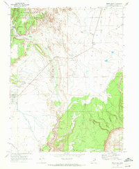
1968 Map of Emery East
USGS Topo · Published 1972About this map
Emery and the smaller settlement of Moore anchor this landscape during the late 1960s, where the high desert terrain of the San Rafael Swell meets the eastern edge of the Manti-La Sal National Forest. The geography is defined by dramatic elevation changes, moving from the irrigated fields near the town centers to the striking geological formations of the Molen Reef and the Coal Cliffs. The path of Muddy Creek carves through the center of the sheet, its importance to the local economy evidenced by the Gaging Station and various irrigation networks. Researchers will find interest in the documented infrastructure of the era, including a Radio Facility, a Gravel Pit, and the local Cem cemetery near the town site. The rugged southern reaches are accessible only by a Jeep Trail, winding through landmarks like Miller Canyon and Molon Seep.
Find a feature on this map
21 named features on this map. Tap any name to fly to it.
Don’t see what you’re looking for? This feature index may not catch every label — zoom into the map to look around manually.
Map Details
Editions of this 1968 Emery East Map
2 editions found
Other maps of this area

1885 · Manti
USGS Topo · 1:250,000

1885 · Fish Lake
USGS Topo · 1:250,000

1895 · Manti
USGS Topo · 1:250,000

1896 · Fish Lake
USGS Topo · 1:250,000

1922 · Wasatch
USGS Topo · 1:31,680

1923 · Castle Dale
USGS Topo · 1:62,500

1925 · Castle Dale
USGS Topo · 1:62,500

1925 · Acord Lakes
USGS Topo · 1:62,500

1953 · Emery 1 NE
USGS Topo · 1:24,000

1953 · Emery 1 SE
USGS Topo · 1:24,000