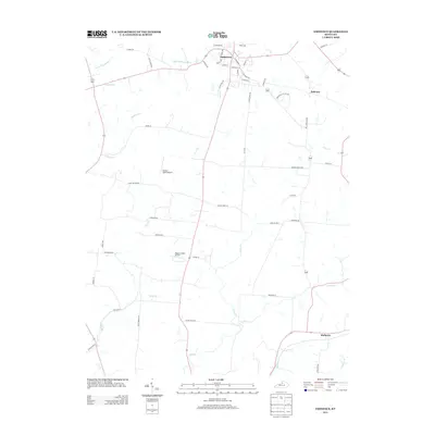
2013 Map of Eminence
USGS Topo · Published 2013About this map
Eminence serves as the primary hub of this northern Kentucky landscape, where residential streets like Crabb Ave and E Broadway St branch out into a agricultural countryside. The topography is defined by the headwaters and branches of several significant drainage systems, including the Little Kentucky River in the north and the E Fork Floyds Fork to the west. Evidence of the region’s transit history is preserved in names like Narrow Gage Pike, hinting at former rail alignments, while the modern era is represented by local aviation strips such as Flying C Farms Airport and Rooster Field Airport. Small rural centers like Mulberry sit at crossroads in the southeast, surrounded by a network of creeks including Mulberry Cr and E Clear Cr. The map details many family-named roads, such as Jim Doyle Rd and Clore Jackson Rd, providing a specific geographic record of land use and habitation in this part of Henry County.
Find a feature on this map
54 named features on this map. Tap any name to fly to it.
Don’t see what you’re looking for? This feature index may not catch every label — zoom into the map to look around manually.
Map Details
Editions of this 2013 Eminence Map
This is the sole edition of this map. No revisions or reprints were ever made.
Other maps of this area

1923 · Waddy
USGS Topo · 1:48,000

1925 · Mount Eden
USGS Topo · 1:48,000

1927 · Mount Eden
USGS Topo · 1:62,500

1928 · New Castle
USGS Topo · 1:48,000

1929 · Taylorsville
USGS Topo · 1:62,500

1932 · New Castle
USGS Topo · 1:62,500

1932 · La Grange
USGS Topo · 1:62,500

1954 · Ballardsville
USGS Topo · 1:24,000
1954 · New Castle
USGS Topo · 1:24,000
1954 · Eminence
USGS Topo · 1:24,000