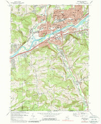
1969 Map of Endicott
USGS Topo · Published 1988About this map
The Susquehanna River corridor forms the industrial and residential heart of this late-1960s landscape, where the Erie-Lackawanna railroad tracks parallel the water and connect the manufacturing hubs of Endicott and Vestal. This era shows a dense network of community institutions, including the Ideal Hosp, En-Joye Park, and numerous parochial schools like St Josephs Sch and St Anthony Sch. North of the river, the suburban growth of Endwell and West Corners transitions into the steep slopes of Bornt Hill.
Find a feature on this map
77 named features on this map. Tap any name to fly to it.
Don’t see what you’re looking for? This feature index may not catch every label — zoom into the map to look around manually.
Map Details
Editions of this 1969 Endicott Map
Other maps of this area

1901 · Apalachin
USGS Topo · 1:62,500

1904 · Binghamton
USGS Topo · 1:62,500

1904 · Apalachin
USGS Topo · 1:62,500

1906 · Catatonk
USGS Topo · 1:125,000

1934 · Castle Creek
USGS Topo · 1:24,000

1935 · Binghamton West
USGS Topo · 1:24,000

1942 · Binghamton West
USGS Topo · 1:31,680

1942 · Castle Creek
USGS Topo · 1:31,680

1943 · Montrose
USGS Topo · 1:62,500

1943 · Le Raysville
USGS Topo · 1:62,500