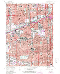
1963 Map of Englewood
USGS Topo · Published 1981About this map
Industrial corridors and dense residential blocks define this urban landscape during a period of significant infrastructure expansion. The Chicago Sanitary and Ship Canal and the South Branch Chicago River anchor the heavy industrial districts, where the Turning Basin facilitates maritime traffic alongside the Illinois Central Gulf and Indiana Harbor Belt rail lines. This 1963 survey, updated with 1970s aerial data, reveals the massive footprint of the Stevenson Expwy and Dan Ryan Expressway cutting through established neighborhoods.
Find a feature on this map
174 named features on this map. Tap any name to fly to it.
Don’t see what you’re looking for? This feature index may not catch every label — zoom into the map to look around manually.
Map Details
Editions of this 1963 Englewood Map
4 editions found
Other maps of this area

1889 · Chicago
USGS Topo · 1:62,500

1890 · Des Plaines
USGS Topo · 1:62,500

1891 · Chicago
USGS Topo · 1:62,500

1891 · Riverside
USGS Topo · 1:62,500

1892 · Calumet
USGS Topo · 1:62,500

1893 · Calumet
USGS Topo · 1:62,500

1893 · Riverside
USGS Topo · 1:62,500

1894 · Des Plaines
USGS Topo · 1:62,500

1900 · Chicago
USGS Topo · 1:62,500

1900 · Des Plaines
USGS Topo · 1:62,500