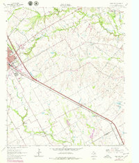
1962 Map of Ennis East
USGS Topo · Published 1979About this map
The Southern Pacific railroad corridor anchors this survey of eastern Ellis County, running through the growing hub of Ennis and southeast toward Rice. The landscape is a mix of agricultural plots and small communities like Telico, Creechville, and Alma. This map reveals a significant density of social and educational infrastructure that defined rural Texas life in the mid-century, including the Central High Sch and the Odd Fellows and Rebekahs Home. A network of watercourses, such as Village Creek, Cottonwood Creek, and Cummins Creek, snakes through the territory, occasionally intercepted by industrial features like a Gravel Pit or the infrastructure of the local Sewage Disposal system. The presence of numerous rural religious sites, such as St Johns Ch and Cottonwood Ch, alongside family-named landmarks like the Redwine Cem, makes this an essential document for tracing genealogy and local settlement patterns.
Find a feature on this map
32 named features on this map. Tap any name to fly to it.
Don’t see what you’re looking for? This feature index may not catch every label — zoom into the map to look around manually.
Map Details
Editions of this 1962 Ennis East Map
3 editions found
Other maps of this area

1954 · Dallas
USGS Topo · 1:250,000

1956 · Ennis
USGS Topo · 1:62,500

1958 · Dallas
USGS Topo · 1:250,000

1961 · Chatfield
USGS Topo · 1:24,000

1962 · Emhouse
USGS Topo · 1:24,000

1962 · Ennis West
USGS Topo · 1:24,000

1962 · Ennis East
USGS Topo · 1:24,000

1962 · Rosser SW
USGS Topo · 1:24,000

1962 · Cryer Creek
USGS Topo · 1:24,000
1962 · Bristol
USGS Topo · 1:24,000