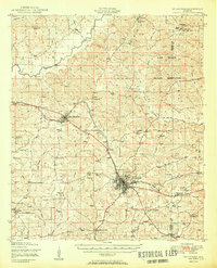
1950 Map of Enterprise
USGS Topo · Published 1950About this map
The Enterprise city center anchor this mid-century portrait of Coffee and Dale counties, showing a landscape defined by small agrarian crossroads and the significant expansion of the Camp Rucker Military Reservation. In the years following the war, the region maintains its rural character through a dense network of country churches and schools like Old Tabernacle Church and Rocky Head School. The Atlantic Coast Line railroad cuts across the terrain, connecting New Brockton to the larger hub at Enterprise and facilitating the local economy. Settlement patterns are concentrated at historic junctions such as Battens Crossroads and Turner Crossroads, while the Pea River and its various tributaries like Double Bridges Creek provide the natural drainage for the rolling Southeast Alabama territory. This document captures the footprint of community life before the era of major highway expansion, preserving the exact locations of family cemeteries and local landmarks like the Municipal Airport.
Find a feature on this map
54 named features on this map. Tap any name to fly to it.
Don’t see what you’re looking for? This feature index may not catch every label — zoom into the map to look around manually.
Map Details
Editions of this 1950 Enterprise Map
2 editions found
Other maps of this area

1942 · Enterprise
USGS Topo · 1:125,000

1948 · Ozark
USGS Topo · 1:62,500

1948 · Brundidge
USGS Topo · 1:62,500

1950 · Ozark
USGS Topo · 1:62,500

1950 · Enterprise
USGS Topo · 1:62,500

1950 · Brundidge
USGS Topo · 1:62,500

1953 · Andalusia
USGS Topo · 1:250,000

1953 · Dothan
USGS Topo · 1:250,000

1954 · Dothan
USGS Topo · 1:250,000

1955 · Dothan
USGS Topo · 1:250,000