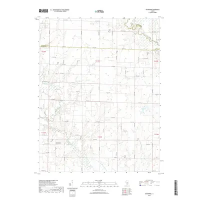
2018 Map of Enterprise
USGS Topo · Published 2018About this map
The settlement of Enterprise sits at the southern edge of Clay County, Illinois, marking a landscape defined by its agricultural grid and winding waterways. This portion of the Illinois prairie is deeply etched by the Little Wabash River and its tributaries, including Elm River and Sycamore Creek, which break the geometric precision of the county roads. The map serves as a detailed record for genealogists, as it preserves the locations of numerous family and community burial grounds such as Laird Cemetery, Evangelical Cemetery, and Zif Cemetery. The terrain is further shaped by drainage efforts, including the Elm River Drainage Ditch, reflecting the local history of managing the low-lying bottomlands for cultivation. Notable landmarks like Robinson Lake and various rural crossings provide specific points of interest within the townships of T1N and T2N.
Find a feature on this map
71 named features on this map. Tap any name to fly to it.
Don’t see what you’re looking for? This feature index may not catch every label — zoom into the map to look around manually.
Map Details
Editions of this 2018 Enterprise Map
This is the sole edition of this map. No revisions or reprints were ever made.
Other maps of this area
1943 · Albion
USGS Topo · 1:62,500
1946 · Albion
USGS Topo · 1:62,500
1948 · Fairfield
USGS Topo · 1:62,500
1948 · Flora
USGS Topo · 1:62,500
1949 · Olney
USGS Topo · 1:62,500
1949 · Flora
USGS Topo · 1:62,500
1958 · Belleville
USGS Topo · 1:250,000
1962 · Belleville
USGS Topo · 1:250,000
1970 · Clay City
USGS Topo · 1:24,000
1970 · Enterprise
USGS Topo · 1:24,000