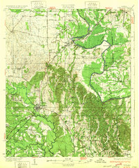
1932 Map of Epes
USGS Topo · Published 1932About this map
The confluence of the Tombigbee River and the Sucharnoochee River anchors this study of the Alabama Black Belt during the early 1930s. The landscape is defined by the winding river systems and the critical transit hubs of Livingston and Epes. The map illustrates a society built on the river-and-rail economy, where the Southern RR and St Louis-San Francisco RR cut across the drainage basins of Alamuchee Creek and Turkey Creek. Rural life is meticulously documented through numerous community institutions, including the Industrial School near Livingston, the Ezell Sch, and several houses of worship such as Wesley Chapel and Bethsalem Ch. This survey, produced by State Geologist Walter B. Jones, captures the region before the widespread modernization of river crossings, still featuring landmarks like Hillman Ferry and McAlpin Bend.
Find a feature on this map
55 named features on this map. Tap any name to fly to it.
Don’t see what you’re looking for? This feature index may not catch every label — zoom into the map to look around manually.
Map Details
Editions of this 1932 Epes Map
4 editions found

Other maps of this area

1927 · Eutaw
USGS Topo · 1:48,000

1929 · Epes
USGS Topo · 1:48,000

1931 · Eutaw
USGS Topo · 1:62,500

1932 · Epes
USGS Topo · 1:62,500

1947 · Forkland
USGS Topo · 1:24,000

1948 · Mc Dowell
USGS Topo · 1:24,000

1949 · Mc Dowell
USGS Topo · 1:24,000

1949 · Forkland
USGS Topo · 1:24,000

1953 · Montgomery
USGS Topo · 1:250,000

1953 · Meridian
USGS Topo · 1:250,000