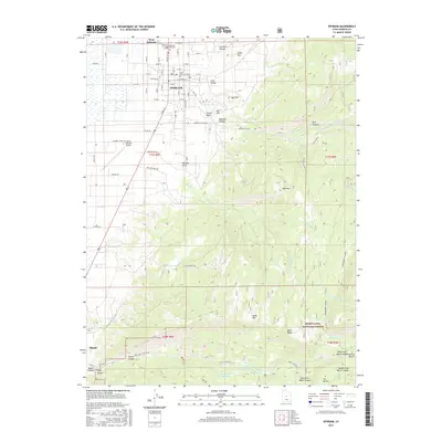
2017 Map of Ephraim
USGS Topo · Published 2017About this map
Ephraim serves as the focal point of this Sanpete County survey, illustrating a high-desert landscape where agricultural grids meet the steep ascent of the Wasatch Plateau. The map captures the campus of Snow Coll and the municipal layout of West Ephraim as they appeared in 2014-2016. The transition from the valley floor to the Manti-La Sal National Forest is marked by significant topographical shifts, including landmarks like Witches Knoll and Bald Mtn.
Find a feature on this map
69 named features on this map. Tap any name to fly to it.
Don’t see what you’re looking for? This feature index may not catch every label — zoom into the map to look around manually.
Map Details
Editions of this 2017 Ephraim Map
This is the sole edition of this map. No revisions or reprints were ever made.
Other maps of this area

1885 · Manti
USGS Topo · 1:250,000

1895 · Manti
USGS Topo · 1:250,000

1922 · Wasatch
USGS Topo · 1:31,680

1956 · Price
USGS Topo · 1:250,000

1960 · Price
USGS Topo · 1:250,000

1962 · Price
USGS Topo · 1:250,000

1965 · Manti
USGS Topo · 1:24,000

1965 · Wales
USGS Topo · 1:24,000

1965 · Black Mountain
USGS Topo · 1:24,000
1966 · Ferron Reservoir
USGS Topo · 1:24,000