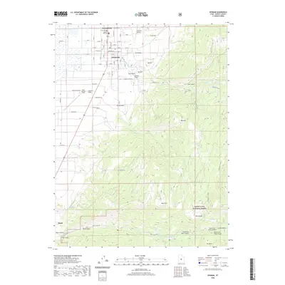
2020 Map of Ephraim
USGS Topo · Published 2020About this map
Ephraim serves as the primary hub of this high-elevation landscape, where the street grid of the Sanpete Valley meets the rising terrain of the Wasatch Plateau. The map documents the transition from the organized blocks of West Ephraim to the deep drainage systems of Ephraim Canyon and New Canyon. Genealogists will find the Ephraim Park Cem and Park Cem clearly marked at the northern edge of town, while researchers of land use can trace the complex network of irrigation and water management through Petes Reservoir and Yearns Reservoir. Southward, the terrain climbs toward the Manti-La Sal National Forest, featuring landmarks like Witches Knoll and Manti Mtn. The inclusion of the Experiment Station and the Manti-Ephraim Airport highlights the mix of scientific research, transportation, and mountain agriculture that sustains this corridor between Ephraim and Manti.
Find a feature on this map
59 named features on this map. Tap any name to fly to it.
Don’t see what you’re looking for? This feature index may not catch every label — zoom into the map to look around manually.
Map Details
Editions of this 2020 Ephraim Map
This is the sole edition of this map. No revisions or reprints were ever made.
Other maps of this area

1885 · Manti
USGS Topo · 1:250,000

1895 · Manti
USGS Topo · 1:250,000

1922 · Wasatch
USGS Topo · 1:31,680

1956 · Price
USGS Topo · 1:250,000

1960 · Price
USGS Topo · 1:250,000

1962 · Price
USGS Topo · 1:250,000

1965 · Manti
USGS Topo · 1:24,000

1965 · Wales
USGS Topo · 1:24,000

1965 · Black Mountain
USGS Topo · 1:24,000
1966 · Ferron Reservoir
USGS Topo · 1:24,000