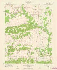
1959 Map of Equality
USGS Topo · Published 1960About this map
The Saline River cuts through this landscape where industrial history meets the northern edge of the Shawnee National Forest. The settlement of Equality serves as a primary anchor near the river, surrounded by a topography defined by the Wildcat Hills and Gold Hill. This area is notable for its legacy of salt production, evidenced by the Negro Spring Salt Well and another Salt Well located near the forest boundary, marking one of Illinois' earliest mineral industries.
Find a feature on this map
41 named features on this map. Tap any name to fly to it.
Don’t see what you’re looking for? This feature index may not catch every label — zoom into the map to look around manually.
Map Details
Editions of this 1959 Equality Map
3 editions found
Other maps of this area

1905 · Eldorado
USGS Topo · 1:62,500

1905 · New Haven
USGS Topo · 1:62,500

1906 · New Haven
USGS Topo · 1:62,500

1906 · Eldorado
USGS Topo · 1:62,500

1916 · Shawneetown
USGS Topo · 1:62,500

1916 · Equality
USGS Topo · 1:62,500

1949 · Paducah
USGS Topo · 1:250,000

1949 · New Haven
USGS Topo · 1:62,500

1950 · Paducah
USGS Topo · 1:250,000

1954 · Paducah
USGS Topo · 1:250,000